I’m asking the public to tell me where they feel belonging in the “nine-county Bay Area.” What does that even mean?
There’s a paradox in studying belonging while excluding people outside of the nine counties. Yet, there has to be some parameters, and the nine-county definition is a commonly-used one.
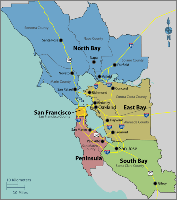
Map of the nine-county Bay Area. Source: Wikipedia // Wikimedia Commons.
I would like this project to be as inclusive and diverse as possible. I aim to achieve geographic diversity within the nine counties. When I was stressing out about this, Haas Arts & Cultural Strategy Coordinator (and artist) Evan Bissell wisely reminded me that no matter how many contributors participate, I can’t possibly be comprehensive in this limited art project.
Here’s my reality check:
“These nine counties include 101 cities, 7.4 million inhabitants and approximately 7,000 square miles of land.”
—Metropolitan Transportation Commission website
The nine counties cover a lot of area
It’s a little intimidating to realize how large this undertaking is when you realize the nine counties’ vastness.
The nine-county Bay Area is larger than Delaware (1,949 square miles) and Connecticut (4,842 square miles) combined.
It’s almost as large as New Jersey (7,354 square miles).
Another way to think of it is if you imagine the municipal organizations that manage transit or air quality in the region, and how many people and levels of staff are needed to assess the area.
A lot of people live here
If the nine counties formed a state, it’d rank 13th most populous below Virginia (8.4 M), and above Washington state (7.2) (Wikipedia).
The nine counties are more populous than the eight least populous states combined.
In fact, more people live in the city of San José (1.035 M) than the five least populous states (South Dakota, North Dakota, Alaska, Vermont, and Wyoming). More people live in San Francisco than South Dakota. More people live in Oakland and Berkeley combined than in Vermont.
I’m mostly familiar with population-dense areas
When I look at the nine-county map, I’m struck by how many outer regions I’m unfamiliar with.
Though I’ve lived in the North Bay, East Bay, and peninsula over 30 years, I don’t know much about Sonoma, Napa, and Solano counties north of Santa Rosa, Napa, and Vallejo. Same with Alameda County east of the regional parks, and the peninsula west of 280. Nor have I ventured often south of San Jose, yet a vast expanse of Santa Clara County extends southward.
This map of population density shows generally less people living in these regions:

Map: “Where we live now — 2010 household density and priority development areas” produced by Darin Jensen, Madeleine Theriault and Mike Jones of the CAGE (Cartography and GIS Education) Lab at U.C. Berkeley’s Department of Geography, and by Thomas Guffey and Michael Stoll of the Public Press. // Source: sfpublicpress.org.
How Areas and Population Compare
To put this in perspective, I did a quick-and-dirty comparison of percentage of square miles versus percentage of population. The colors correspond to the five subregions in the first map of the nine-county Bay Area.

Comparison of percentages of area and population in the nine-county Bay Area.
While 61% of the square mileage of the nine counties falls in the North Bay (Marin, Sonoma, Napa and Solano Counties), only 18% of the population lives there.
About 25% of residents call Santa Clara County home, which covers only 10% in area. And 37% of people live in East Bay (Contra Costa and Alameda Counties), though it constitutes 20% of the square mileage.
Density and San Francisco, Oakland, and San José
I know that many cultural resources are concentrated in San Francisco, Oakland, and Berkeley. I’ve been making an extra effort to reach people outside of those cities.
Though San Francisco, Oakland, and San José make up only 3% of the square mileage, one in five people in the nine counties live in those three cities.
What this means to me is that my outreach efforts to the suburbs and exurbs are worthwhile, but I shouldn’t be surprised if SF, Oakland, and San Jose are well-represented (if not overly represented due to network effects).
There’s roughly equal numbers of people living in the entire North Bay as there are in San Francisco, Oakland, and San José. But I’m not sure how to conduct a comparable amount of outreach in the North Bay, which is 21X the area of the three major cities.
More info
For a friendly 8-minute intro to the nine-county designation, listen to KQED’s Bay Curious episode, “How Do You Define the ‘Bay Area’?”
Find more maps in “Where Exactly Is “the Bay Area” by Egon Terplan and Sarah Jo Szambelan (June 19, 2018) on SPUR.org.
